Map Thread XXII

Long live the new Map Thread, have fifteen different Virginias!


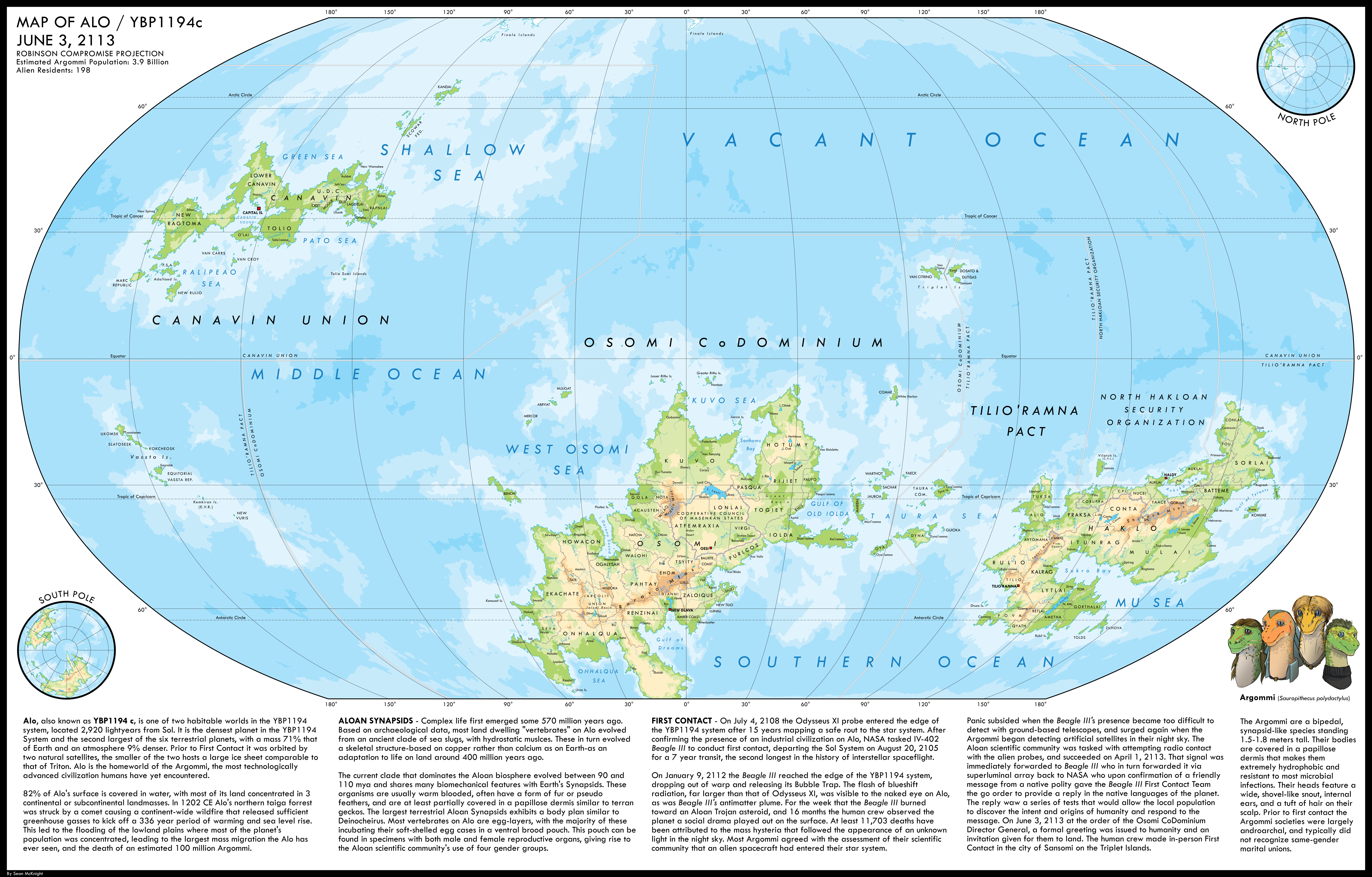
A1 – The Dominion of Virginia

Capital: Richmond
Government: Federal parliamentary constitutional monarchy in personal union with the United Kingdom of Great Britain and Ireland

The Dominion of Virginia occupies a peculiar position in Anglophone North America. For one, it is the second-largest of them in terms of area, only surpassed by the massive yet sparsely populated Rupertia (which Virginia barely borders in the north). Secondly, it is the second-most populated Anglophone state on the continent, only surpassed by its northeastern neighbor New Britain.

What really sets Virginia apart is its continued loyalty to the British crown in an era where republicanism is spreading on the North American continent. Besides the aforementioned Rupertia, it is the last remaining state still in union with the UK in the region. Alebamon, Canada, Carolina, the Haudenosaunee Confederacy, New Britain, and Tsalagihi-Cumberland have all cut their ties with their “mother country” over time, but the Old Dominion stays proud!

With its vast territories surrounding the southern portions of the Great Lakes and its rich mining history along the Allegheny mountains, Virginia has become a wealthy and diverse nation. However, while its populace remains loyal to the crown, dissatisfaction with the Westminster-style system of government has increased drastically, both in the indigenous provinces (which are only represented in the upper house, the Chamber of Provinces) and in the urban areas, where a greater diversity of parties leads to most constituencies in the Chamber of Deputies being elected with less than forty percent of the vote.
1687550893219.png


A small additition to this entry in particular. These are all the nations on the North American mainland (aka excluding the Caribbean) that used to be part of the British Empire. The Oceti Sakowin & Siksikaitsitapi were joint protectorates with the Spanish (and later the Republic of Louisiana). The Haudenosaunee Confederacy, due to not being a joint protectorate, was included in the list of countries that severed its ties to the UK despite never having the British monarch as its head. The same cannot be said for Alebamon and Tsalagihi-Cumberland. Alebamon was founded as a native-only state with the British monarch as its united head, while Tsalagihi-Cumberland was originally the Cumberland province within Carolina but has since gained independence thanks to its dominant Cherokee population.

You can also find some notes for New Britain in particular, along with its flag, here.

EDIT: Changed the borders for Oceti Sakowin and Siksikaitsitapi slightly and made the text more uniform.
 
Last edited:
What's a Saint Thomas Christian?
That...depends who you ask, but mostly they are Syriac Orthodox.

Some are West Syrian (close theological cousins to the Copts and Armenians), and some are East Syrian (Church of the East). But both of those have segments that claim continuity with the Apostle Thomas.

EDIT: To make it even more complicated, some have become subordinated to the Pope, whilst others haven't.
 
View attachment 839558
Some further progress of my mapping effort. Apart from Finland, you can notice some interesting additions in the Middle East
What is the situation in Poland?
View attachment 839463

Random WI: What if Edward I Longshanks successfully organised the dynastic union between England and Scotland by arranging the marriage between Edward II and Margaret Maid of Norway. This leads to a years earlier Union of the Crowns and no claim on France, which i chose by butterflies to go to Joan II of Navarre and by jure uxoris Phillip of Evreux.
The Norwegians keep the Orkney and Shetland Islands? I’m game.
Ah, new map thread. Might as well post these two embiggens: South Korea and the Philippines.

View attachment 839024
View attachment 839025
Given the lack of influence of Korea in Central Asia, should we guess that the Koreans deported their in the past have all returned to Korea? Not that all would I suppose, given how culturally they would have changed over the generation. Still, bound to be safer there. Belarus looks rather odd. Hopefully Ukraine isn’t having too trouble populating that territory, along with all the Russian stuff they took.

Another submission. Once again this is not mine’s. This is from Reddit. It’s created by TheRustlerofJimmiez.

Basically a world where the Arab world is united and Iran is bigger. And where both nations are about to go to war again. The map shows the concentration of Iranians in the UAR.

View attachment 839521
Alas, I find the Arabs uniting only slightly less likely than the Spanish colonies in Latin America uniting after independence. Their map is interesting in how it shows how high population areas can look small compared to vast swathes of areas where few if any humans live.
 
Alas, I find the Arabs uniting only slightly less likely than the Spanish colonies in Latin America uniting after independence. Their map is interesting in how it shows how high population areas can look small compared to vast swathes of areas where few if any humans live.
I think it’s possible the Arabs can unite. But the PODs need to be good.

And yeah I really like demographic maps like these because they add a lot to the worldbuilding.
 
Are you grouping all Catholics as one? I thought some of the Eastern Catholics elsewhere in the Middle East were mapped separately but I might be mistaken.
Eastern Catholic churches are shown in separate colour but with the grey borders between them .
What is the situation in Poland?
The outline shows borders of areas where the Lutherans were majority preWW2.Same is being shown in Azerbaijan and Turkey
 
USSR videogame.png


Very different from my normal content, because this is actually an early map for my Kamenev timeline:

This is supposed to be a mapping of a gameplay a guy named George did and sent to his friend, Charlie. This is the e-mail:

Sent from: ***********@gmail.com
Sent to: **************@gmail.com
Date and hour: 23rd July 2008

hey, charlie!

how are you? i'm particularly ok, but being here in kentucky enjoying the vacation is stopping me from playing games.
fortunately, i think i have time for this one. this is a map i made all by myself using paint.net about cccp. its an enjoyable ds title about grigry zinovyev. yeah, you know? the russian from the ussr that was shot? in this game, you need to make him survive through 209 weeks (every week is a turn).

ITS AWESOME! the upper screen shows the map, where you can administer the provinces individually. you need to get them green through investing money in infrastructure, industrialization, that stuff. some can be easy to get green, but those in siberia are IMPOSSIBLE (which well its realistic in sme way))
the lower screen shows the general state of the union and changes you can make. the way in which you make zinovyev survive is basically doing things good. the problem is that its a little hard and you have to balance between the faulty economy after the nep, the workers and the power with other politicians of the poltburo. the way you do this is managing the finances, building factorties and other stuff for the economy, which is harder than what you think. you also need to manage the widespread protests, get the soviet delegates on your side, make the conditions better, and give them rights without angering the nepmen (i swar those guys are a PAAAAAAIN). lastly, you need to get the politburo on your side. normally there are four important factions: the vanguadists of rykv, the reformists of kamenev the trotskyists and the stalinists with other minor factions like the syndicalists or the zhentdel. normally getting them on your side depends a lot on your authoritarianism which is normallly decided by your attitude to the peopla and your management of thee conomy and some other things. you can also choose reforms that will determine the path you choose and what politician you'll help. those stuff contribute to your overall stability in a scale of -5 to +5, economy growth through every week and also support on a scale of 0 to 100. then those ones contribute to your weekly review, which sums up and gives grades (F, E, D, C, B, A, S). if you're over a certain grade, that changes based on difficulty, you will amaneg to survive the murder attempt on zinovyev (that happened in real life), which is challenging and i really like it.

there are five difficulties, and i decided to choose the hardest one: revolutionary. its a pain, i swear, im going to scream to god if stalin coups me AGAIN with the help of dzershinksy. but overall, its really fun. the game makes events for you in which you manage to actually get to know the politicians, like if they were characters. they made me sympathize for STALIN!

even if its a little frutrating, i think you should try it because i loved it. 9/10
 
That...depends who you ask, but mostly they are Syriac Orthodox.

Some are West Syrian (close theological cousins to the Copts and Armenians), and some are East Syrian (Church of the East). But both of those have segments that claim continuity with the Apostle Thomas.

EDIT: To make it even more complicated, some have become subordinated to the Pope, whilst others haven't.
...
One of the many reasons I can't be bothered to keep up with a Faith.
 
The Cold War: Curtains Galore
1962.png

After the Indians placed Vishnu Missiles in the Kuban region of Russia, the world held its breath. These missiles could reach Cairo, and, due to technically being in a neutral nation's land, were not forbidden by the Treaty of Hanoi. Luckily, the clock wasn't ready to strike midnight just yet. Good ol' diplomacy won out, and both the Vishnu Missiles in Kuban and the "People's Revolutionary Hammer Missiles" in Al Habesh were withdrawn. However, the Cold War didn't end there.
1962 factions.png

Green = United Nations
Blue = Integralist Entente
Red = Cairo Accords
Purple = Pact of Steel
Gold = Co-Prosperity Sphere
 
The Cold War: Curtains Galore
View attachment 839621

After the Indians placed Vishnu Missiles in the Kuban region of Russia, the world held its breath. These missiles could reach Cairo, and, due to technically being in a neutral nation's land, were not forbidden by the Treaty of Hanoi. Luckily, the clock wasn't ready to strike midnight just yet. Good ol' diplomacy won out, and both the Vishnu Missiles in Kuban and the "People's Revolutionary Hammer Missiles" in Al Habesh were withdrawn. However, the Cold War didn't end there.
View attachment 839637
Green = United Nations
Blue = Integralist Entente
Red = Cairo Accords
Purple = Pact of Steel
Gold = Co-Prosperity Sphere
Is that a Korean led Co-Prosperity Sphere?
 
Top