Well, everyone knows that Finnish people don't exist.Finland? There is no Finland. You have been mistaken, as the next webfind proves:
View attachment 887701
You are using an out of date browser. It may not display this or other websites correctly.
You should upgrade or use an alternative browser.
You should upgrade or use an alternative browser.
Return of Horrible Educational Maps
- Thread starter Westphalian
- Start date
Where's North Korea? Or the entire Warsaw Pact?
And half of Eritrea for some reasonWhere's North Korea? Or the entire Warsaw Pact?
Where's North Korea? Or the entire Warsaw Pact?
And half of Eritrea for some reason
At least they got North Yemen in exchange, I guess?
I think that's meant to be Djibouti?And half of Eritrea for some reason
Why are all the Central Asian 'stans marked as independent states in 1975?Where's North Korea? Or the entire Warsaw Pact?
And Lawd that map projection
>Imply anything is a fair trade when Yemen is one half of the equation s_sAt least they got North Yemen in exchange, I guess?
Don't think it was made as educational but I don't know where else to put this one
Well, that would make <redacted due to Current Politics> very different. And possibly easier.Don't think it was made as educational but I don't know where else to put this one
I wonder what is Russia supposed to be if China is the European Union. It would remain just Russia lol?
Don't think it was made as educational but I don't know where else to put this one
No worries, if you need educational maps then have the next one from reddit:
What makes it even worse is that the redditor who posted it said that it was from a schoolbook of the early 2000s and supposed to show the current world. Although mind you, with those borders that map can't really be pinpointed to any specific date.
Super Peru, Space Filling West Africa, even bigger USSR, separate Papua and New Guinea, independent British Cameroons, big Oman, and strange Ethiopian borders...No worries, if you need educational maps then have the next one from reddit:
View attachment 888497
What makes it even worse is that the redditor who posted it said that it was from a schoolbook of the early 2000s and supposed to show the current world. Although mind you, with those borders that map can't really be pinpointed to any specific date.
It's clearly from before the Finland-USSR Winter War of 1940, as Finland still has a northern coast.that map can't really be pinpointed to any specific date
No, wait, it's clearly from after 1949/1953, since there's both West and East Germany and both North and South Korea.
No, wait, it's clearly from before 1922, as there's no internal Irish border.
No, wait, uhh, help, ... no, I give up.
And where's Cyprus?
With the exception of the line dividing China from the USSR in Western China and the Southern border of Ethiopia reaching the sea, I think every border on there was used at some point in the 20th century. Just lots of other missing borders.Super Peru, Space Filling West Africa, even bigger USSR, separate Papua and New Guinea, independent British Cameroons, big Oman, and strange Ethiopian borders...
It is obviously during the part of the 20th century when Canada controlled all of the shore of Lake Ontario.It's clearly from before the Finland-USSR Winter War of 1940, as Finland still has a northern coast.
No, wait, it's clearly from after 1949/1953, since there's both West and East Germany and both North and South Korea.
No, wait, it's clearly from before 1922, as there's no internal Irish border.
No, wait, uhh, help, ... no, I give up.
And where's Cyprus?
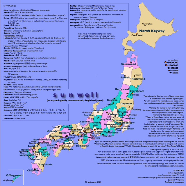
Nice. "The Republic of Vancouver Island"Finland? There is no Finland. You have been mistaken, as the next webfind proves:
View attachment 887701
Well, it seems things have gone south in Northern Ireland.Don't think it was made as educational but I don't know where else to put this one
France lolI wonder what is Russia supposed to be if China is the European Union. It would remain just Russia lol?
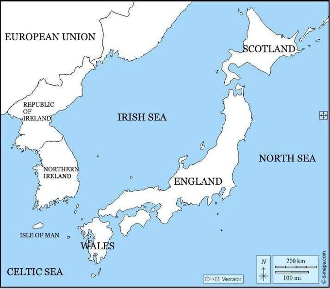
Sweet, now I've finally got a reason to share this one:Well, it seems things have gone south in Northern Ireland.
It's an anglicized map of Japan. All the names are the same, just, well, anglicized.
edit: and I got it from here. https://soranews24.com/2020/08/01/a...-might-be-named-if-they-were-part-of-england/
Share: