Pinsk vs. Novgorod?

Why was Novgorod, not Pinsk the most important waypoint on the Road from Varangians to Greeks?

Consider it as follows:

Crossing a water divide involves a portage over some distance where the headwaters on both sides are small streams. Also optionally portages of rapids on lower courses of major rivers.

Dnieper has a rapid stretch on lower course. Upwards of Dnepropetrovsk, Dnieper is unobstructed to upstream of Smolensk.

There are five major water paths from Dnieper to Baltic. East to west, they are:
  1. Portage to headwaters of Lovat. Down Lovat to lake Ilmen, then down river Volkhov with a short portage of Volkhov rapids to lake Ladoga, then river Neva to Baltic
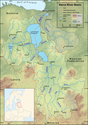
  2. Portage to headwaters of Velikaya. Down Velikaya to lake Peipsi, then down river Narva with short portage of Narva rapids and waterfall to Baltic
  3. Portage to headwaters of Western Dvina. Down Western Dvina with a long stretch of rapids from Jersika to Riga to Baltic
  4. Up tributaries Pripyat and Yaselda. Portage to Schchara. Down Shchara and Nemunas to Baltic.
  5. Up tributaries Pripyat and Pina. Portage to headwaters of Mukhavets. Down Mukhavets, Western Bug and Vistula to Baltic.
How did these routes compare, in 8th...11th century?
Why did Novgorod (on route 1, near exit of Volkhov from Ilmen) become so prevalent over Pinsk (on route 5, on confluence of Pina and Pripyat)?
 
Last edited:
Pinsk didn't even exist until the late 11th century.

Yes, and why? Pripyat river did exist in 8th and 9th century. So did the tributaries Yaselda and Pina, and low water divides to Shchara in Nemunas basin and Mukhavets in Visla basin.
What made these crossings so uninteresting to 8th...11th century Varyags, compared to the crossings to Smolensk from Western Dvina (where Polotsk was founded), Velikaya (where Pskov was founded) and Lovat (where Novgorod and Lovat were founded)?
 
What made these crossings so uninteresting to 8th...11th century Varyags, compared .... Velikaya (where Pskov was founded) and Lovat (where Novgorod and Lovat were founded)?

Novgorod was part of the way-more-important Volga trade route, so that's an easy answer there, Polotsk and Smolensk itself stood on the reasonable West Dvina-Dniepr route. Pskov is a bit of a mystery to me, because the Velikaya doesn't easily link anywhere. A real Varangian-to-Greek route without the early Russian state on the Dniepr itself basically isn't very convincing archaeologically. As to why Pinsk didn't develop after such a state was established, that's not something I can answer offhand.
 
Last edited:
Novgorod was part of the way-more-important Volga trade route, so that's an easy answer there,
Not obvious that it was the more important.
But yes, it explains it.
There were 3 major crossings Volga to Ladoga:
  1. Belozero to Vytegra, then to Lake Onega and Svir
  2. To Tikhvinka and Syas, to Ladoga
  3. Up Tvertsa, crossing at Vyshni Volochek, down Msta to Volkhov, then to Ladoga.
Novgorod is at the junction of Ilmen-Lovat route to Dnieper with Msta route to Volga. So it may not have been the best route to Dnieper, but had the routes to both Dnieper and Volga.
Polotsk and Smolensk itself stood on the reasonable West Dvina-Dniepr route. Pskov is a bit of a mystery to me, because the Velikaya doesn't easily link anywhere.
Examining the map of the upper courses of Velikaya and Lovat, around Velikiye Luki and Nevel, it is not clear to me that the crossing Lovat to West Dvina around Vitebsk was particularly easier than the crossing Velikaya to Vitebsk.
But, as noted, Novgorod had the alternative Msta route to Volga, and Pskov did not.
A real Varangian-to-Greek route without the early Russian state on the Dniepr itself basically isn't very convincing archaeologically. As to why Pinsk didn't develop after such a state was established, that's not something I can answer offhand.

How much was the river trade on 8th...14th century Visla and Bug? How about Nemunas?
 
Not obvious that it was the more important.

In the early period, in both Russia and Scandinavia, finds indicating trade are far more likely to have come from the Volga than the Dniepr, particularly silver coinage. The balance isn't even close. The distribution of early cities in Russia also suggests the same thing - Beloozoro and Rostov in particular would not make sense unless there was constant traffic, and after the decline of Dniepr Rus, Zalesye becomes the centre of everything again. 14th/15th c. trade and raid patterns by Novgorodians also suggests that getting into the Volga waterway was a much commoner occurrence than getting to the Dniepr, absent a dominant state along the Dniepr itself.

How much was the river trade on 8th...14th century Visla and Bug? How about Nemunas?

Hard for me to say, once again. Maybe Augenis or one of our Polish posters can help?
 
Pskov is a bit of a mystery to me.

But its raise was (AFAIK) in the XIV century due to the Hanseatic trade (settlements on the site of the modern Narva existed at least since the early XI century and in the XIV the city got Lübeck City Rights ), not to the Vikings and Livonia was just "next door" as well.

300px-Narva_basin_map.svg.png
 
How much was the river trade on 8th...14th century Visla and Bug? How about Nemunas?
Nemunas was an alternative to Daugava as the route from Dnieper to the Baltic sea, but Dauguva was always the more important one. A variety of reasons - you cannot reach Nemunas from Dnieper directly and instead need to cross through various tributaries, and Nemunas also flows into the Curonian Lagoon, which is like 3 meters deep on average, and this severely limits the size of the ships you can send through this route. The fact that the Nemunas route was also a lot more dangerous because of the tribes inhabiting its surroundings didn't help either.

During the late 12th century and early 13th century, Lithuanian dukes, despite controlling the Nemunas valley, projected power towards the Daugava in an attempt to control the trade route there - this alone tells how much more important the Daugava was than Nemunas.
 
Nemunas was an alternative to Daugava as the route from Dnieper to the Baltic sea, but Dauguva was always the more important one. A variety of reasons - you cannot reach Nemunas from Dnieper directly and instead need to cross through various tributaries,
Tributaries, headwaters - what´s the difference? Is there any relevance whether it is Narew or Bug which is called the tributary?
On the other hand, the crossing between Shchara and Yaselda is easy enough that Oginsky canal was built there in 18th century. No canal was built between Dnieper and Daugava - that crossing must have been harder.
and Nemunas also flows into the Curonian Lagoon, which is like 3 meters deep on average, and this severely limits the size of the ships you can send through this route.
Irrelevant. You cannot send 3 metre deep drawing ships up the rapids of Daugava either.
Nor did 9th or even 13th century sailors find Curonian Lagoon a problem. Look at the Skuldelev ships, mid-11th century.
The deepest drawing one, the big merchant ship Skuldelev 1, drew at most 150 cm loaded.
Hanseatic cogs of 12th...14th century were deeper and needed deeper ports... at something like 200 cm draught. Still suited to Klaipeda Strait.
During the late 12th century and early 13th century, Lithuanian dukes, despite controlling the Nemunas valley, projected power towards the Daugava in an attempt to control the trade route there - this alone tells how much more important the Daugava was than Nemunas.

They did not control Memel Castle. How much did they try to take it?
 
On the other hand, the crossing between Shchara and Yaselda is easy enough that Oginsky canal was built there in 18th century. No canal was built between Dnieper and Daugava - that crossing must have been harder.
As I stated in the recent Dnieper-Daugava canal thread, that canal never materialized not because of any terrain difficulties, but because of lack of interest (the importance of the Dnieper-Daugava route had long since dwindled in the 18th and 19th centuries) and later, the outbreak of WW1.

The Oginski Canal was Oginski's pet project and went through his domains, so its existence doesn't say anything about whether or not it was easier. The distance between Dnieper and Daugava in the Smolensk area is more or less the same as the length of the Oginski Canal.

They did not control Memel Castle. How much did they try to take it?
Memel Castle was constructed in 1252, half a century after the Lithuanian expansion towards the Daugava had been defeated.
 
As I stated in the recent Dnieper-Daugava canal thread, that canal never materialized not because of any terrain difficulties, but because of lack of interest (the importance of the Dnieper-Daugava route had long since dwindled in the 18th and 19th centuries) and later, the outbreak of WW1.

And of course an idea of building such a canal somewhere in the XVI - XVII centuries (even if it was technically possible) was not practical based upon the geopolitical considerations. Whatever traffic existed prior to the XII century, it was not there anymore, the low flow of the Dnieper had been blocked by the Khanate and Kiev as a final destination became absurd.
 
Irrelevant. You cannot send 3 metre deep drawing ships up the rapids of Daugava either.
Nor did 9th or even 13th century sailors find Curonian Lagoon a problem. Look at the Skuldelev ships, mid-11th century.

That's all fine and interesting (no irony) but rather irrelevant.

Who
was going to build a canal in the XI - early XII century? This was seemingly the only period when there was more or less serious commercial traffic by that route but it does not look like the technical possibility was quite there. Unless I'm thoroughly misinformed, the main area of expertise of the disunited Lithuanian tribes of that period had been raiding, not canal (or any other) construction.

By the late XII Kiev lost its position as the main princedom of Rus, being substituted by Vladimir, and even before it was destroyed by the Mongols it was looted and destroyed by Andrey Bogolubsky (1169) . On the other end of the line we have what? Archbishopric of Riga, Livonian Order and the Grand Duchy of Lithuania. Somehow I have problems imagining Lithuania (which, AFAIK, was not even formally united until mid-XIII) circa XII - XIII century being engaged in the canal construction.

Period between XIII and mid-XVII century also does not look promising due to the numerous wars, shifting borders, questionable commercial sense and unquestionable absence of the funds if we are talking PLC period: why would the Lithuanian Sejm raise money for that enterprise if it could not even raise money for defending Livonia? Besides, Kiev being a part of the Kingdom of Poland, why would Lithuanian Sejm give money on something that was going to benefit only the Polish magnates? Or why the Polish Sejm give money on something that would potentially benefit only the Ukrainian "kruliata" but not the magnates of the Great Poland?

Starting from mid-XVII and all the way to the Partitions the idea would be even more preposterous: after 1667 Kiev became a border town, the canal would be within a spitting distance from the Russian border, the Dnieper became a border between the PLC and Tsardom of Moscow and Riga was in the Swedish (and from the early XVIII in Russian) hands.

So you have to wait until the late XVIII (Partitions) when the whole area went under the Russian control but by that time the idea did not have economic sense: major traffic flows (even from Riga) had been going elsewhere.
 
Who was going to build a canal in the XI - early XII century? This was seemingly the only period when there was more or less serious commercial traffic by that route but it does not look like the technical possibility was quite there. Unless I'm thoroughly misinformed, the main area of expertise of the disunited Lithuanian tribes of that period had been raiding, not canal (or any other) construction.
Not canals then. The Oginsk and Kobrin canals were built in 18th century, as was Vyshni Volochek canal. Tikhvin and Maria canals were built in early 19th century.

But absence of actual canal at Vyshni Volochek did not stop the use of portage and making Novgorod and Tver important through the use of the trade route.
So, how about a pair of river ports on Shchara and Yaselda, and a short overland portage to contact them? Like Principality of Grodno using the river route down Nemunas to a seaport and trading over Baltic?

Portaging was a routine thing on the trade routes but in each specific case the question is about the economic reasons for the traffic at each specific period. Transit routes from Baltic to the Black sea seems to belong to the reasonably early period and then they are pretty much dying out.
 
Portaging was a routine thing on the trade routes but in each specific case the question is about the economic reasons for the traffic at each specific period. Transit routes from Baltic to the Black sea seems to belong to the reasonably early period and then they are pretty much dying out.

How important was Visla-Pripyat transit route from 9th to 12th century?
 
Look, the idea is yours not mine. How am I supposed to know beyond obvious fact that it ceased to be important in the later times?

The question was not only to you.
The capital region of 10th century Poland was around Poznan - on Warta, but above Notec confluence - and Gniezno.

The capital of Masovia was not yet at Warszaw - it was at Plock. On Visla - and below the Bug confluence.

Where was the border between Kiev state and Poznan state in 10th century?
 
My five cents, maps of hoards of Islamic coins. Sorry, they are in Russian, hope, you can understand what is where by rivers.
They say, that before 833 year ways 2-4 were not in use (generally)
asTEdgyq0BbaUnARpmlE28gYc6nUe37zkX6uNIuhwbKQnwBBaZv1lqTTvAGKNJfyRGTCHm9eSA6IUnkuO3TH-1xXOuLx-CDP_N-J3I3PYIMTnmzQs6IoI0w60nRNO0l_


Starting from 850s the third way starts to work, from 890s - the fifth one:
JKZeqKcErxxv45OQTOvBVnG7THXEITsPz08_JCwciqeJQt07Njl2oap0dVCoPzb2V6EBcsPhH44PKvXCegs_PanbDh7nhZ8QYe6GMdKu2o2DxgF_YTephZK3IYcr2WGU


And in X century you can see all ways, and even the sixth one, by Dnister
HtlFpspQ__k5fQ83FoQXFRfrd0WXzBaRVJJKDjUlxTf7_eXWMBpb1H0LbSMgiZjW5iuagDHss9tpoc6qG-0s3e6-nfZGBgG9QOos60GoACuB68NxKrSKyOAsUefqenE7


Maybe, trade was not so great, and Novgorod was a trade center already, and it was to dangerous or to expensive to look for another way and made this way. They say, cities, towns and villages were present all the way from Novgorod to Kiev and to Black sea, where merchants were able to rest at nights (about 30 km between them or something like this) - and merchants were defended by Russian princes.
And when trade became bigger, the third way became popular - Riga was a rich city in XIII century, if I remember correctly.
One more reason - strong Novgorod did not allow to grow competitors. Novgorod fighting against Polotsk - the main trade center on the third way; and Novgorod defeated Pskov on the second way.
And for ways 4 and 5 - it was a trade way from Kiev to Krakow and Prague and further to west - for merchants who wanted to trade directly to west/to Kiev. Maybe, it was too long way to Baltic.
 
Top