I dont know which one is right. i made both versions just in case. Any one knows?

.jpg")
Last edited:
Could it be because I am using the date of 800AD as a reference, and you are using 100AD? Here the maps i used as sources.From what I know, and can find online in Dutch, the short answer is "Neither, but the right-hand one is closer". The Flevomeer should definitely be closed up like you have it there. The left-hand one looks more like the 1500s to me.
But it's apparent that a huge part of the coastal areas were either "wadden", tidal mudflats, or "veenmoeras", fenland. As these terrains are very close to sea level already, the precise definition of what's land and what's nominal sea (i.e. at an average high tide) is difficult. The topography can also shift drastically with each major storm, or every spring when you get the pulse of meltwater coming down the Rhine from Germany and the Alps.
So the right-hand one needs quite a lot more of your blue-grey patches to show areas that would have looked green from the air but would see you ankle- to waist-deep in brackish water and surrounded by reeds and salt grasses if you tried walking through them. It should also have a more solid coastline, there's good agreement that the coastal dunes were far more contiguous then than now, with far fewer openings for rivers to flow out.
I've seen some fairly decent and properly researched maps over the years, though of course I can't find them online to link to. The good stuff tends to be in large, expensive hardback atlases or paleogeological research papers. But these two give an idea of what I'm getting at, even though as "Roman era" maps they're probably focused on the 100s AD, rather than 500.
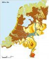
From the 60s or early 70s most likely, but still OK. Blue shows tidal flats, pink shows fenland, green shows riverbank clays that flood frequently and need raised houses or dikes for permanent settlement. Yellow is dry land (inland) and coastal sand dunes.
View attachment 891626
[Source]
More modern, though done by a freelance cartographer so this is the free small sample of a for-profit large-scale map, and I can't find his sources listed.
Green is fenland, buff is dry land, yellow is dunes and beach, and blue-grey is tidal flats.
View attachment 891627
[Source]